
Official name: Republic of Hungary
Area: 93,036 km 2
Population: 10,084,000 (July 2005)
Capital city: Budapest
Official language: Hungarian
Currency: Forint (HUF)
The national flag and the arms of the Republic of Hungary
National anthem
)
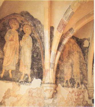
Source: Sights of Hungary. Editor-in chief: Pálfy Katalin. Well-Press Publisher, 2001. inner cover
Hungary is situated in the southern zone of Central Europe, in the centre of the CarpathianBasin, which is surrounded by the East Alps, the Carpathians and the Dinaric Mountains. The country sits lower than its neighbouring countries. The ocean current considerably decreases in the territory of Hungary; however, the continental climate is still not predominant. The Adriatic Sea is only 200 kilometres from the border of Hungary. For this reason some temporate features may be effective in the Hungarian climate, natural vegetation and the hydrology of rivers. Hungary has the shape of a basin, which is favourable for transport due to the country’s central location and to the fact that there are no relief obstacles. However, it is less favourable in terms of the water resourches because the rivers bring considerable amounts of pollutants from abroad. The relief of Hungary is characterised by a low height above sea level and a low level of verticular configuration. 68% of Hungary’s territory is lowland (less than 200 metres above sea level), 30% is a hilly region (between 200-400 metres) and only 2% is for hills higher than 400 metres. Very few patches of land reach above 600 metres.
The Republic of Hungary with a territory of 93,036 km 2 is among the small-sized states in Europe. Hungary’s territory is less than 1% of that of Europe. The country is centrally located in the Carpathian Basin, whose territory is approximately 330,000 km 2. The country is not an individual geographical unit and its borders nowhere separate natural regions. From among the six large regions of Hungary– the Great Plain, the Small Plain, the lower part of the Alps, the Transdanubian Hills, the Transdanubian Mountains and the North-Hungarian Mountains – only the Transdanubian Mountains lie exclusively in the territory of Hungary.
The other five large regions extend over the borders. The geographically open borders connect Hungary to the neighbouring countries rather than separate it. These geographical conditions also suggest some kind of interdependence.
Due to its geographical location, Hungary belongs to the temperate zone with four seasons, more specifically, to the temperate continental area. Due to the fact that Hungary has a small territory, a low height above sea level and a low level of verticular configuration, there are no significant differences between the climatic conditions of individual regions. Based on the distance from the ocean, the continental features (more considerable sunshine duration, lower level of cloudiness, larger temperature variation, less precipitation) grow from the west to the east. The same features grow from the the frame of mountains at the border towards the lowland centre of the basin due to the nature of the basin. In Hungary, which is so small that the largest distance between its western and eastern borders is 520 kilometres, the effects of the nature of the basin are really significant. Therefore the most continental region is located in the middle of the Great Plain (the region of the middle part of the Tisza River) rather than in the eastermost parts of the country.
Due to the small extension from the north to the south (320 kilometres), there are no significant differences between the amounts of solar energy. The range of cloudiness is much more important. It shows the lowest values in the middle of the Great Plain (about 50%), and it is the highest alongside the western border (nearly 70%). The effects of these two factors are reflected by the annual totals of sunshine hours and also by solar radiation. In the south of the area between the Danube and the Tisza River the annual totals of sunshine hours is 2100, however, alongside the western border it is only 1700-1800. The annual totals of global solar radiation, especially its summer maximum, are really favourable for the growing of corn and fruit and also for tourism. Hungary’s annual mean temperature is 8-11 ˚C. The highest temperatures are recorded alongside the south-eastern border.
)
Source: Geographical Atlas. Pauz Westermann, 1999. p.8.
Annual mean temperature
The configurations of the terrain in the Carpathian Basin - which is situated in the zone of western winds -, and the nature of the basin considerably modify the prevailing wind directions. North-west winds are prevailing west of the line of the Tisza River and north-east winds are usual east of the river. Due to the protection provided by the mountains, mean wind speed in Hungary (2-4 m/s) is much lower than in areas to the west in Europe.
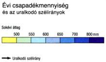
From among climatic elements the largest differences between areas are shown by the amount of precipitation. Hungary’s wettest areas are situated near the south-west border (over 800 mm/year) and the driest regions can be found alongside the middle part of the Tisza River (less than 500 mm/year). The distribution of precipitation in time is unequal but not unfavourable. Hungary has the highest amount of precipitation from the end of spring to the beginning of summer, which provides enough timely precipitation for grain and row crops. In certain years, however, there are significant differences as compared to the averages, and also some unpredictable monthly extremety. Droughts, particularly in summer, cause a lot of harm and crop failure. It is unfavourable that lands are covered with snow for the shortest period of time (30-35 days/year) in the southern part of the Great Plain, which is a critical agricultural region.
)
Source: Geographical Atlas. Pauz Westermann, 1999. p.8
Annual precipitation (average of many years) and prevailing wind directions
The nature of the basin is one of many determining factors in Hungary’s hydrography. The waters flow from the frame of mountains towards the inner part of the basin. 90% of the surface waters of Hungary are brought to the country by the rivers flowing from the neighbouring countries. An negative side effect of this ’import’ is that the country receives a considerable amount of pollutants with the water. The country does not have a dense hydrological network and it is becoming continually thinner in the east.
The Danube is the axis of the network of rivers in Hungary and the Carpathian Basin.
The length of the section of the Danube in Hungary is 417 kilometres, 140 kilometres of which form the border between Hungary and Slovakia. Its water is utilised primarily as drinking and industrial water. The total length of the Danube in Hungary is a navigable waterway throughout the year (with the exception when the water level is low in autumn or when it is covered with ice on rare occasions in winter). The river provides Hungary with saltwater access; however, this terminus is at the Black Sea, far away from the main centres of world trade.
Thus far , the most significant intervention in the life of the river in Hungary has been the Bõs-Nagymaros dam plan. As a Hungarian-Czecho-Slovakian joint venture, the construction started in the 1970s, and was abandoned by Hungary at the end of the 1980s for environmental protection reasons. Ever since that time Bõs-Nagymaros has been an unsolved heritage burdened with environmental and political problems.
The second largest river of Hungary, the Tisza, is a slow river with a small gradient and extreme flow rates. Its length in Hungary is 596 kilometres. The level of the Tisza varies greatly through out the year. The process of straightening the river, done during the last century, created a large number of dead channels and branches that were cut off from the new river bed. (As a result of this straightening, the river has become nearly 40% shorter than its original length.) A profitable exploitation of the river for economic purposes is considerably hindered by its extremes in water output. The canals branching off the Tisza (the Western and the Eastern Main Canal) are important for irrigation.
Both of the large navigable rivers flow from the north to the south parallel with each other. A more significant east-west trade route is greatly impeded by this.
There are two significant floods each year on the Hungarian rivers. The flood in early spring (in March) is caused by thawing of the snow in the Alps, the Carpathians and in the country itself. The flood in early summer (the so-called spring flood) is in connection with precipitation.
Our lakes are shallow; therefore they rapidly warm in summer and freeze-over in winter. To utilize it, tourism has already taken precedence – especially in the summer season - over traditional utilisation of fishing and reed harvesting. Overcrowding on the Balaton and Lake Velencei is considered as a problem for environmental protection.
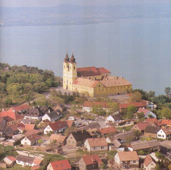
The Balaton (598 km 2) is the largest warm water lake in Europe and the largest lake in Central and Western Europe. Its length is 78 kilometres, and 15 kilometres at its widest and 1.5 kilometres at its narrowest (at the Tihany peninsula). The deepest point of the lake can be found in front of the Tihany peninsula, the so-called Well of Tihany is 11.5 metres in depth. Its average depth is 3 metres. The varied relief of the coast and its favourable summer climate has made the lake lying at the southern foot of the Bakony Hills one of the most important tourist locations.
Tihany – the Abbey with the Balaton in the background
Source: Balázs Dercsényi: Ungarn. Merhávia-Kaleidoszkóp, 1999. p. 72.
One quarter of the extraordinarily shallow Lake Fertõ(average depth: 1 metre, maximum depth: 4 metres) belongs to Hungary. Reed covers half of the surface of the lake. Near the lake a national park was established with joint Austrian and Hungarian management.
Hungary is very rich in groundwater. What is more, it is one of the richest countries in Europe in terms of mineral waters. These waters contain valuable minerals (carbon dioxide, iron, alum, iodine and sulphur), therefore they are perfectly suitable for medical purposes.
At present, due to human intervention, natural vegetation can be found on a maximum of 9-10% of the whole territory of Hungary. The vegetation is very rich in species despite the small area and featureless relief of the country (about 2,200 species of plants). Hungary, where the climatic conditions are varied, is a meeting point for Atlantic, continental and mediterranian plant species.
The map of vegetation in Hungary is not determined by individual plant species but by a characteristic territorial grouping of these species, known as plant communities. Wooded steppes prevail in the plains and deciduous forests are characteristic in the hills and mountains. There are several species depending on the location, its climatic, hydrologic, pertographic and soil conditions. The communities of deciduous forests in the hills and mountains are composed of oak trees in the lower, warmer and drier areas and of beeches in the higher, cooler and wetter places. Indigenous pinewoods (fir, spruce and larch trees) can be found in the Bakony Hills and in the Sopron and Kõszeg Hills, which are arms of the Alps. Approximately 17-18% of the territory of Hungary is covered with woods ( mostly planted).
)
The fauna and flora of Hungary: 1 butcher’s broom, 2 Bulbocodium versicolor, 3 red deadnettle, 4 dandelion, 5 military orchid, 6 lemon lily, 7 summer snowflake, 8 globe daisy,
9 globe flower, 10 dwarf iris, 11 cotton grass, 12 wind flower, 13 limonium gmelini,
14 stipaborysthenica, 15 yellow flag, 16 echiumrussicum, 17 smoketree,
18 rose daphne, 19 white stork, 20 great bustard, 21 Balkan wall lizard, 22 European otter, 23 souslik (citellus), 24 wild cat , 25 wild boar, 26 elk
Source: Magyar Nagylexikon. 12. kötet Magyar Nagylexikon Kiadó, 2001. pp. 446-447.
The most important natural resource in Hungary is the diversified soil, whichmostly yieldswell and gives hopes of developed agriculture. Meadow soils prevail in the plains and various types of forest soils can be found in the hilly and the mountainous regions. 45% of arable land can be found in sloping areas in Hungary. The soil of these lands is more and more endangered by erosion. More than 70% of the original soil profiles have been damaged by erosion in the foreground of the Transdanubian Hills and the mountains.
Concerning public administration, Hungary is divided into 19 counties and the capital city of Budapest.
The counties in Hungary:
)
Source: Akadémiai Kislexikon. 2. kötet Akadémiai Kiadó, 1990. Annex
(Map Key:
Capital city Settlement
County seat Over 1 million inhabitants
Motorway 100,000 -1 million inhabitants
Main road 25,000-100,000 inhabitants
Main railway line less than 25,000 inhabitants
Incorporated area)
The population of the country was 10,084,000 in July 2005.
The population density is 108 people/km 2, which is about the European average. The highest density can be found in metropolitan Budapest, in big towns and their neighbourhood. It is low in regions where there is little arable land, in the hilly regions and in the Transdanubian areas of small villages.
Density of population:
)
Source : Földrajzi Atlasz. Pauz Westermann, 1999. p. 9.
Hungarians, who belong to the Finno-Ugric language family, live among Slavic-, Romanian- and German-speaking nations, far away from their linguistically related nations (Finns, Estonians and some peoples in Russia). Hungarian is the mother tongue of nearly the entire population of the country. The percentage proportion of those who consider themselves as national ethnic minorities is very low. There have been some changes in the number of ethnic minorities in the last fifty years. The reasons for this were a mass relocation of the German population after World War II, an exchange of Hungarian-Slovak populations and the assimilation of some people of ethnic minorities into the Hungarian population.
From among national ethnic minorities the number of German people is the largest (the “Swabian” people, whose ancestors settled after the Turkish occupation of Hungary). Most of them live in Baranya, Tolna and Komárom-Esztergom counties and near Budapest. From among various Slavic minorities, Slovaks live mostly in Békés and Komárom-Esztergom counties and close to Budapest. Croats live in Bács-Kiskun, Zala, Vas and Gyõr-Moson-Sopron counties and Serbs in Bács-Kiskun and Csongrád counties and also near Budapest. Slovenian people preferliving in settlements near the border in Vas county. Romanian people live mostly in Békés and Hajdú-Bihar counties in settlements near the Hungarian-Romanian border. The ethnic minorities in Hungary also include Greek, Bulgarian, Ruthenian and Ukrainian people.The Roma population living in Hungary – whose number is over 400,000 – also make up an ethnic minority. They live in almost every settlement but most of them live in Borsod-Abaúj-Zemplén, Szabolcs-Szatmár-Bereg and Jász-Nagykun-Szolnok counties and in Budapest.
The Constitution of Hungary and a special Act endow ethnic minorities with equal rights, allow them to use their mother tongue and provide education and culture in their mother tongue. They have the rights to establish cultural and economic organisations and minority local governments.
It is estimated that the total number of Hungarian people in the world is approximately 15 million. Around 3 million Hungarian people live in the Carpathian Basin beyond the borders of Hungary, in the neighbouring countries.
Hungarian people beyond the state borders
2005 |
10 years ago |
|
Romania |
1,432 million |
1,6 million |
Slovakia |
520,000 |
567,000 |
Serbia |
290,000 |
341,000 |
Ukraina |
152,000 |
156,000 |
Croatia |
17,000 |
22,000 |
Source : Pester Lloyd. Nr. 37, 14. September 2005. p. 4.
Hungarian people live in smaller communities in Slovenia and Austria as well. People of Hungarian origin live scattered in the US, Canada, South-America, Western Europe, Israel and Australia. Those who live in the Carpathian Basin but beyond the borders of Hungary became dislocated from their country with the political decisions made after the two world wars. Hungarian people living in other countries left their native country for economic (unemployment) and political reasons (eg. the revolution in 1956).
Since the 1990s there has been an unfavourable change in the demographic as opposed to a slow increase in the former decades. The national population is decreasing in contrast to the world population increase. The birth rate is rapidly decreasing while the death rate is inceasing. This is true in every county of Hungary. The lower number of births is a complex problem and can only be explained by a combinaton of factors. They are as follows: low average incomes, people get married later (50 years ago the majority of women got married at the age of 19-20, currently between the ages of 23-25), the number of marriages has been decreasing, the number of divorces has increased and most women are employed, which often impedes the decision to have more children. Immigration and emigration – which are an international phenomena -, do not have a significant influence on the national population. The number of emigrants is not considerable and the immigrants are most often Hungarian people living in the neighbouring countries (Transylvania-Romania, Voivodina-Serbia) who emigrate because of the unfavourable economic or political conditions prevailing there. Life expectancy at birth has an effect on the future number of the population, which is 67 years for men and 75 years for women. Both (especially that of men) are lower than those in other developed European countries. The low indexes are closely connected with the state of health of the population.
The future outlook for the population of Hungary is to decrease further. If this negative tendency prevails, it will seriously affect the future of the nation in the coming decades. Therefore it is a vital national interest to increase the number of births and life expectancy by providing the necessary economic, health and moral conditions that may promote these goals.
Age pyramid
Men Women
)
Source: Évszázadok Statisztikája. KSH, 2001. p. 30.
(Key: Age
Male Female
The territory of Hungary is divided into six greater regions on the basis of natural geographical factors:
Great Plain,
Small Plain,
Lower Alps,
Transdanubian Hills,
Transdanubian Mountains
North-Hungarian Mountains
The Great Plain is not only the largest region of Hungary but also the most homogeneousterritory in terms of relief and climate. Known all over the world as a natural Hungarian region, the ’puszta’ is a kind of cultural steppe. It has been shaped by human intervention throughout the past century. It used to have forests that have been eliminated as a result of river management and deforestation. The majority of the Great Plain is flatland. It has the best quality arable lands of fertile loess-covered meadow soil. The Great Plain is traditionally divided into two parts by the Tisza River; the territory between the Danube and the Tisza and the region east of the Tisza River.
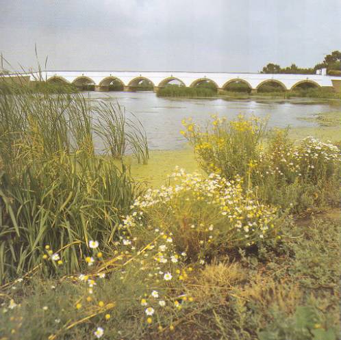
The largest city beyond the Tisza river is Debrecen, the so-called ’Calvinist Rome’, the centre of Protestantism in Hungary. The Calvinist Great Church is the most important historic building of the city and it has also been the location of several historical events. Apart from that, Debrecen is also famous for its educational institutions, collections and galleries (Calvinist School, the Great Library and the Déri Museum). Hajdúszoboszló, a town situated nearby, is famous for its spa. In Hortobágy tourists can enjoy the special flora and fauna as well as the ethnographic traditions of the region.
Hortobágy – the Bridge with Nine Arches
Source: Balázs Dercsényi: Ungarn. Merhávia-Kaleidoszkóp, 1999. p. 31.
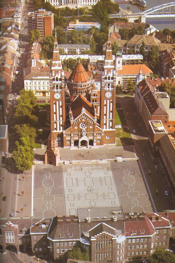
Szeged is the largest city in Southern Hungary. It is situated at the meeting point of the Tisza and the Maros rivers. Szeged is also a university town and the economic and cultural centre of the region. One of the symbols of the city is the Cathedral built on the initiative of the citizens of Szeged who survived the flood in 1879.
Szeged – the Cathedral
Source: Balázs Dercsényi: Ungarn. Merhávia-Kaleidoszkóp, 1999. p. 35.
The total area of the Small Plain (9000 km 2) is less than one tenth of the territory of the Great Plain. Less than half of its area, only 4000 km 2, is situated within the borders of Hungary. Here the Danube formed its largest alluvium in Europe (Szigetköz, Csallóköz). Its gravel bed contains a large amount of drinking water. The location of the Small Plain is most favourable for road, rail and water transport.
The Lower Alps is connected to the highest mountainous region of Europe by the two lowest spurs of the East Alps (Soproni and Kõszegi hills) and by the gravel cover spread by the rivers flowing from Austria.
The largest city of Western Transdanubia is Gyõr, which is a meeting point of rivers and historic ages. A significant work of art of Hungarian Baroque, the Esterházy Palace of Fertõd can be found in this region. Joseph Haydn spent most of his life at Fertõd and composed 150 pieces of music including 14 operas there.
Fertõd – Esterházy Palace
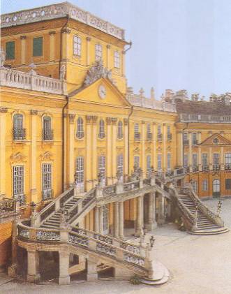
Source: Balázs Dercsényi: Ungarn. Merhávia-Kaleidoszkóp, 1999. p. 54.
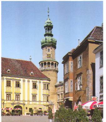
The citizens of a nearby town of Soprondecided to belong to Hungary after World War I by holding a referendum. Therefore Sopron is often called the ’most loyal town’. In the old part of the town there are several buildings set on Roman foundations (the castle wall from the Middle Ages, Renaissance and Baroque style town-houses, Gothic churches and palaces from the 19-20th centuries). The town of Szombathely was founded by Emperor Claudius along ’Borostánykõ’ (amber) Road in about 50 A.D. and he called it Colonia Claudia Savaria. The town is also recognised as the birthplace of Márton, canonized as the Bishop of Tours.
Sopron – Fire-Watch Tower
Source: Balázs Dercsényi: Ungarn. Merhávia-Kaleidoszkóp, 1999. p. 58.
The Transdanubian Hills lie in a east-west direction from Zala Valley to the Danube. Its borders are drawn by the Balaton in the north and Dráva Valley in the south. Two block mountains rise above the hilly region, like two islands; the Mecsek and Villányi mountains. The natural resources of the hills are mostly utilised as pastureland and those in the mountains are used in mining ore, coal and stone, and in tourism in caves and mineral spas.
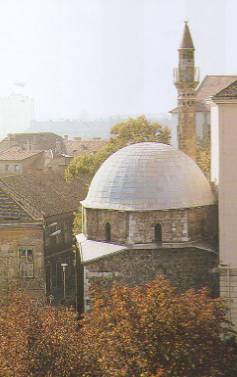
The most significant city in South Transdanubia is Pécs. In Roman times the province of Pannonia was an important settlement known as Sopianae. The first king of Hungary, Saint Stephen, founded a see in this place and several centuries later - besides Buda - Pécs became the centre of Renaissance culture in Hungary. In the 16th and 17th centuries the town was under Turkish rule. Today two djamis and a turbe (mosques) bear witness to that age. During the industrial boom since the middle of the 19th century several important factories were established, including the world-famous Zsolnay ceramics factory.
Pécs – the Djami of Jakováli Hasszán
Source: Balázs Dercsényi: Ungarn. Merhávia-Kaleidoszkóp, 1999. p. 44.
The Transdanubian Mountains lying from the north-western edge of the Balaton to the line of the Danube is the only region in Hungary which is situated only in the territory of Hungary. In the karst regions of the about 200 kilometer long mountains of south-west and north-east situation, a network system of groundwaters has been formed. Karst water plays an essential role in the water sypply of the region. Some of the mountains (Bakony, Vértes) are famous for brown coal and bauxite mining. Several caves and 123 medical waters and thermal springs have given the Buda Hills a unique and natural value. The hills have special configuration, which provides protection for its relief, woods, mineral sources and stones. All these factors have played a significant role in the history of the settlement of Budapest since ancient times. A part of the Buda Hills belongs to the capital city and the increasingly intensive construction of this area endangers these natural resources.
Budapest – Gellért Spa
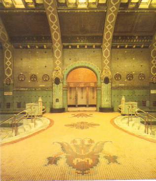
Source: Balázs Dercsényi: Ungarn. Merhávia-Kaleidoszkóp, 1999. p. 91.
The centre of the Bakony region is Veszprém, a town of Hungarian queens, who were crowned and buried there. King Saint Stephen founded the first Hungarian see in Veszprém. The wife of the king, Gizella from Bavaria, also took part in the foundation of Szent Mihály (St. Michael) Cathedral.
Veszprém – Gizella Chapel
Source: Balázs Dercsényi: Ungarn. Merhávia-Kaleidoszkóp, 1999. p. 62.
The North Hungarian Mountains lie as an extension of the Transdanubian Mountains to the north. This region has the coldest climate in Hungary.
The mountainous region is the richest area of the country in woods (oak in the lower parts and beech higher up). On the southern slopes of the mountains where the sunny conditions prevail, are found some historic wine-districts (Eger, Tokaj). The rich and varied supplies of mineral resources of the North Mountains (brown coal, lignite and ores) etablished the conditions for the early development of industry in the region. Visegrád Mountain, which is part of the area, lies west of the Danube. The Danube Bend, a breakthrough valley of the river, which is one of the regions of Hungary richest in natural and historic spots, can be found there. The highest peak of Hungary (Kékes – 1014 metres) is situated in the Mátra Mountains. In the caves of the Bükk Mountains scientists have found several prehistoric fossilized human remains.
Esztergom, Danube Bend – Archiepiscopal Cathedral
)
Source: Balázs Dercsényi: Ungarn. Merhávia-Kaleidoszkóp, 1999. p. 81.
The centre of the region of North Hungary is Miskolc, which has been an important trade and communication junction for centuries. The town of Eger is situated at the south-western foot of the Bükk Mountains. Saint Stephen founded a see there in 1009. Eger had its golden age in the second half of the 15th century. In 1552 the defenders of its fortified castle forced the attacking Turks to withdraw. The Turks were only able to occupy Eger at the end of the century. The minaret in town reminds people of theTurkish occupation. Large-scale construction commenced after the Turks left. Baroque style became prevalent in the downtown area of Eger.
Aggtelek National Park: in the karstland of North Hungary, near the border with Slovakia (1985)
Balaton Higland National Park: north of the Balaton and in the territory of the Small Balaton (1997)
Bükk National Park: in North Hungary, in the territory of the Bükk Mountains
(1976)
Duna-Dráva National Park: several long stripes of land in South Transdanubia
(1996)
Duna-Ipoly Nationa Park: north of Budapest, in the territory of Pilis and Börzsöny Mountains (1997)
Fertõ-Hanság National Park: in the north-west of Hungary, in the subsisting areas of the formerly large marshland of Lake Fertõ and the Hanság (1991)
Hortobágyi National Park: in the area beyond the Tisza, in the territory of Hortobágy (1973)
Kiskunsági National Park: an area between the Danube and the Tisza rivers with several types of landscape and natural habitat (1975)
Körös-Maros National Park: in the South Great Plain in the territory of the Körös and the Maros river system (1997)
Õrség National Park: West-Transdanubia (2002)
Budapest: the Danube Bend and the Castle District in Buda (1987), and Andrássy Road and its neighbourhood (2002)
Budapest – Parliament with the bank of the Danube in the background
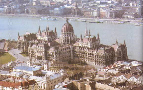
Source: Balázs Dercsényi: Ungarn. Merhávia-Kaleidoszkóp, 1999. p.94.
Hollókõ: a traditional Palóc (Palots) village in Nógrád county (1987)
Caves in the Aggtelek and Szlovakian karstlands (1995)
Aggtelek – Stalactite Cave
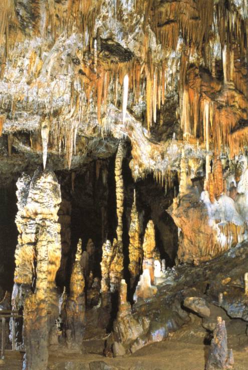
Source: Magyarország nevezetességei. Főszerkesztő: Pálfy Katalin. Well-PRess Kiadó, 2001. p.48.
Pannonhalma Benedictine Abbey and its natural environment (Gyõr-Moson-Sopron county)
(1996)
Pannonhalma – Library of the Benedictine Abbey
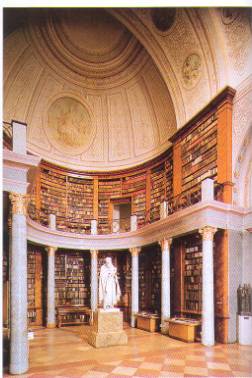
Source: Balázs Dercsényi: Ungarn. Merhávia-Kaleidoszkóp, 1999. p. 60.
A Hortobágyi National Park (1999)
Pécs old Christian burial vaults (2000)
Cultural landscape of Fertõ Lake (2001)
Tokaj wine-district (2002)
Sources of the textual material: Bora Gyula – Nemerkényi Antal: Magyarország földrajza. Nemzeti
Tankönyvkiadó,1994. pp. 9-77.
Bernek Ágnes – Bora Gyula – Nemerkényi Antal – Sárfalvi Béla:
Társadalomföldrajz.Tankönyvkiadó, 2002. pp. 110-116.